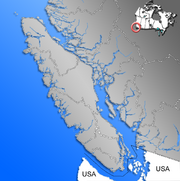
Vancouver Island
 Vancouver Island |
|
| Geography | |
|---|---|
| Location | Pacific Ocean |
| Area | 32,134 km2 (12,407 sq mi) |
| Area rank | 43rd |
| Highest elevation | 2,198 m (7,211 ft) |
| Highest point | Golden Hinde |
| Country | |
|
Canada
|
|
| Province | |
| Largest city | Victoria (pop. 331,491) |
| Demographics | |
| Population | 740,876 [1] (as of 2008) |
| Density | 22 /km2 (57 /sq mi) |
Vancouver Island is a large island in British Columbia, Canada. It is one of several North American locations named after George Vancouver, the British Royal Navy officer who explored the Pacific Northwest coast of North America between 1791 and 1794.
The island is 460 kilometres (290 mi) in length and 80 kilometres (50 mi) in width at its widest point. It is the largest island on the western side of North America at 32,134 km2 (12,407.0 sq mi) and the world's 43rd largest island, Canada's 11th largest island and Canada's second most populous island after the Island of Montreal. The 2001 census population was 656,312. British Columbia statistics in 2008 estimated the population at 740,876.[2] Nearly half of these (331,491) live in Greater Victoria. Other major cities on Vancouver Island include Nanaimo, Port Alberni, Parksville, Courtenay, and Campbell River.
The island was originally named "Quadra and Vancouver Island" in commemoration of the friendly negotiations held by Spanish Commander of the Nootka Sound settlement Juan Francisco de la Bodega y Quadra, and British Naval Captain George Vancouver on Nootka Sound in 1792, to find a solution to the Nootka Crisis.
Contents |
Geography and environment
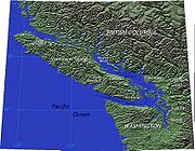
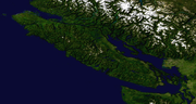
Vancouver Island is located in the southwestern corner of the province of British Columbia. It is separated from the mainland of British Columbia by Johnstone Strait, and Queen Charlotte Strait on the northeast, and by the Strait of Georgia on the southeast, which along with the Strait of Juan de Fuca along its southwest separate it from the United States (the Straits of Georgia and Juan de Fuca are now officially also part of the Salish Sea, which includes Puget Sound as well). West of the island is the open Pacific Ocean, while to its north is Queen Charlotte Sound.
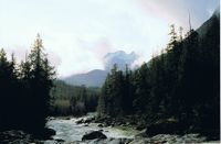
The Vancouver Island Ranges run most of the length of the island, dividing it into a wet and rugged west coast and a drier, more rolling east coast. The highest point in these ranges and on the island is the Golden Hinde, at 2,195 metres (7,201 ft). Located near the centre of Vancouver Island in 2,500 square kilometres (620,000 acres) Strathcona Provincial Park, it is part of a group of peaks that include the only glaciers on the island, the largest of which is the Comox Glacier. The Golden Hinde is also part of the Karmutsen Formation, which is a sequence of tholeiitic pillow basalts and breccias. The west coast shoreline is rugged and in many places mountainous, characterised by its many fjords, bays, and inlets. The interior of the island has many lakes (Kennedy Lake, northeast of Ucluelet, is the largest) and rivers. Vancouver Island formed when volcanic and sedimentary rock scraped off the ancient Kula Plate and plastered against the continental margin when it was subducting under North America 55 million years ago.
The climate is the mildest in Canada, with temperatures on the coast even in January being usually above 0 °C (32 °F). In summer, the warmest days usually achieve a maximum of 28-33 degrees Celsius. However, the rain shadow effect of the island's mountains, as well as the mountains of Washington's Olympic Peninsula, creates wide variation in precipitation. The west coast is considerably wetter than the east coast. Average annual precipitation ranges from 665 centimetres (260 in) at Henderson Lake on the west coast (making it the wettest place in North America) to only 64 centimetres (25 in) at the driest recording station in the provincial capital of Victoria on the southeast coast's Saanich Peninsula. Precipitation is heaviest in the autumn and winter. Snow is rare at low altitudes but is common on the island's mountaintops in winter.
A notable feature of Vancouver Island is the extension of Mediterranean-type summer dryness to latitudes as high as 50°N. Only in the extreme north of the island near Port Hardy is the rainfall of the driest summer month as much as one fifth that of the wettest months from November to March. West coasts of other continents at similar latitudes have a practically even distribution of rainfall through the year.
Vancouver Island lies in the temperate rainforest biome. On the southern and eastern portions of the island, this is characterized by Douglas-fir, western red cedar, arbutus (or madrone), Garry oak, salal, Oregon-grape, and manzanita; moreover, Vancouver Island is the location where the Douglas-fir was first recorded by Archibald Menzies;[3] Vancouver Island is also the location where the tallest Douglas fir ever was recorded. This southeastern portion of the island is the heavily populated region of Vancouver Island and a major area for recreation. The northern, western, and most of the central portions of the island are home to the coniferous "big trees" associated with British Columbia's coast — western hemlock, western red cedar, Pacific Silver Fir, yellow cedar, Douglas-fir, grand fir, Sitka spruce, and western white pine. It is also characterised by bigleaf maple, red alder, sword fern, and red huckleberry.
The fauna of Vancouver Island is similar to that found on the mainland coast, with some notable exceptions and additions. For example, grizzly bears, mountain goats, porcupines, moose, skunks, coyotes, and numerous species of small mammals, while plentiful on the mainland, are absent from Vancouver Island. The island does support most of Canada's Roosevelt elk, however, and one species — the Vancouver Island Marmot — is unique to the island. The island's rivers, lakes, and coastal regions are renowned for their fisheries of trout, salmon, and Steelhead. It has the most concentrated population of cougars in North America.
It is a commonly-heard urban myth in British Columbia that Vancouver Island is the same size as the whole of the United Kingdom. This is untrue: at 12,407 square miles in area, it is around one eighth the size of the UK, whose land area is 94,060 square miles.
Geology
Vancouver Island lies along the Pacific Ring of Fire; it is the most seismically active region in Canada. In 1946, the Forbidden Plateau in the east of the Vancouver Island Ranges was the epicenter of an earthquake that registered 7.3 on the Richter scale, the strongest ever recorded on land in Canada. See 1946 Vancouver Island earthquake.[4]
Vancouver Island was the location of the observation of the episodic tremor and slip seismic phenomenon.
History
Indigenous people
Vancouver Island has been the homeland to many main indigenous peoples for thousands of years.[5] These are the Kwakwaka'wakw, Nuu-chah-nulth, and Coast Salish. Kwakwaka'wakw territory includes northern Vancouver Island, with parts of the mainland, then Nuu-chah-nulth spanning from the northern western part of the island, to the south, covering the west coast, and Coast Salish covering the lower eastern part. Their cultures are connected to the natural resources abundant in the area.
European exploration
Europeans began to explore the island in 1774, when rumours of Russian fur traders caused Spain to send a number of expeditions to assert its long-held claims to the Pacific Northwest. The first expedition was that of the Santiago, under the command of Juan José Pérez Hernández. In 1775, a second Spanish expedition under the Spanish Peruvian captain Juan Francisco de la Bodega y Quadra was sent. By 1776 Spanish exploration had reached Bucareli Bay including the mouth of the Columbia River between Oregon and Washington, and Sitka Sound.
Vancouver Island came to the attention of Britain after the third voyage of Captain James Cook, who spent a month during 1778 at Nootka Sound, on the island's western coast. Cook claimed it for the United Kingdom. The island's rich fur trading potential led the fur-trader John Meares to set up a single-building trading post near the native village of Yuquot (Friendly Cove), at the entrance to Nootka Sound. The building was removed by the end of 1788.
The island was further explored by Spain in 1789 with Esteban José Martínez, who established the settlement of Yuquot and the artillery battery of Fort San Miguel at Friendly Cove, which Spain called Puerto de San Lorenzo de Nuca. This was to be the only Spanish settlement in what would later be Canada. Asserting their claim of exclusive sovereignty and navigation rights, the Spanish force seized the Portuguese-flagged British ships. The two nations came close to war in the ensuing Nootka Crisis, but the issues were resolved peacefully with the first Nootka Convention in 1790, in which both countries recognized the other's rights to the area. The terms of the convention called for Spain to turn over the Britain the buildings and land that had been seized in 1789. For this purpose the British Naval Captain George Vancouver was sent to Nootka Sound in 1792. His Spanish counterpart in the negotiations was Juan Francisco de la Bodega y Quadra, who was commandant of Santa Cruz de Nuca in 1792. Vancouver had sailed as a midshipman with Cook. The negotiations between Vancouver and Bodega y Quadra ended in a deadlock with nothing resolved. Vancouver insisted the entire Spanish establishment be turned over, but Quadra held that there were no buildings seized in 1789 and the only possible land was a tiny and useless cove nearby. The two decided to refer the entire matter back to their respective governments. The friendly meeting bewteen Quadra and Vancouver led the former to propose that the island be named after both: "Quadra and Vancouver Island", which became the original name. As Spain's influence in the area diminished in the 19th century, the name was shortened to the current "Vancouver".
In 1792, the Spanish explorer Dionisio Alcalá Galiano and his crew were the first Europeans to circumnavigate Vancouver Island. On April 8, 1806 Captain John D'Wolf of Bristol, Rhode Island sailed the Juno to Newettee, a small inlet in the northwestern promontory of Vancouver's Island. The Captain described Newette as one of the southernmost harbors frequented by American fur traders at lat. 51 degrees N. and long. 128 degrees. He relates that since Captain Robert Gray of Tiverton, Rhode Island sailed the Columbia River in 1792, the trade of the Northwest coast had been almost entirely in the hands of Boston merchants, so much so that the natives called all traders "Boston Men." [6] While we know this island today as Vancouver Island the English explorer had not intentionally meant to name such a large body of land solely after himself.[7] In his September 1792 dispatch log report for the British Admiralty, Captain Vancouver reveals that his decision here was rather meant to honour a request by the Spanish Peruvian seafarer Juan Francisco de la Bodega y Quadra that Vancouver:
- "would name some port or island after us both in commemoration of our meeting and friendly intercourse that on that occasion had taken place (Vancouver had previously feted Quadra on his ship);....and conceiving no place more eligible than the place of our meeting, I have therefore named this land...The Island of Quadra and Vancouver."[8]
Bodega y Quadra wrote, however, that it was Vancouver who made the suggestion of combining their names to designate some geographical feature.[9]
If Vancouver had been vain as some writers had charged, he could have chosen to name the entire Island exclusively after himself instead of sharing its name with Quadra and placing the latter's name before his. The newly discovered "Quadra's and Vancouver's Island" was the most prominent name on maps of the coast, and appeared on most [contemporary] British, French and Spanish maps of the period. But as Spanish interests in the region dwindled, so did Quadra's name. The Hudson's Bay Company played a major part in the transition; by 1824 'Vancouver's Island' had become the usual designation in its correspondence for the island.[10] A quarter of a century later, Vancouver Island had become such a well known geographical feature, that the founding of the Colony of Vancouver Island in 1849 gave this name full official status.[11] Period references to "Vancouver" referred to Vancouver Island until the naming of the city of Vancouver in 1885.
British settlement
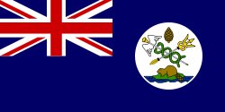
Shortly thereafter, in 1846, the Oregon Treaty was signed by the British and the U.S. to settle the question of the U.S. Oregon Territory borders. It awarded all of Vancouver Island to what would be Canada, despite a portion of the island lying south of the 49th parallel. In 1849, the Colony of Vancouver Island was established. Following the brief governorship of Richard Blanshard, James Douglas, Chief Factor of the Hudson's Bay post, assumed the role in 1851.
The first British settlement on the island was a Hudson's Bay Company post, Fort Camosack, founded in 1843, and later renamed Fort Victoria.[12] Fort Victoria became an important base during the Fraser Canyon Gold Rush in 1858, and the burgeoning town was incorporated as Victoria in 1862. Victoria became the capital of the colony of Vancouver Island, then retained that status when the island was amalgamated with the mainland in 1866. A British naval base, including a large shipyard and a naval hospital, was established at Esquimalt, in 1865 and eventually taken over by the Canadian military.
The economic situation of the colony declined following the Cariboo Gold Rush of 1861-1862, and pressure grew for amalgamation of the colony with the mainland colony of British Columbia (which had been established in 1858). The colony's third and last governor, Sir Arthur Kennedy oversaw the union of the two colonies in 1866.
Economy
Vancouver Island's economy outside Victoria is largely dominated by the forestry industry, with tourism and fishing also playing a large role. Many of the logging operations are for paper pulp, in "2nd growth" tree farms that are harvested approximately every 30 years. In recent years the government of British Columbia has engaged in an advertising program to draw more tourists to beach resorts such as Tofino.
Logging operations involving old-growth forests such as those found on Clayoquot Sound are controversial and have gained international attention through the efforts of activists and environmental organizations.
Between Vancouver Island and the Canadian mainland there are several high voltage power cables, as well for DC, HVDC Vancouver-Island, but also for AC. See Powerlines connecting Vancouver Island with Canadian Mainland.
There is also a developing IT field on Vancouver Island. High Speed Internet is delivered to the island from Shaw and Telus. Wireless Internet connections can be found all over the island, many free for public use. Many coffee shops provide free wireless Internet access and charge an average of five cents a minute for using their computers.
Transport
Sea
Marine transport is very important to Vancouver Island for access to the mainland of British Columbia and Washington. There are no bridges connecting the island to the mainland, although the idea of building one has been brought up many times. The only vehicle access to Vancouver Island is via ferries operated by BC Ferries, Washington State Ferries and Black Ball Transport Inc. There are six vehicle ferry routes:
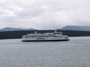
- BC Ferries
- Tsawwassen (38 km south of Vancouver) - Swartz Bay (20 mi (32 km) north of Victoria)
- Crossing time: 1 hour 35 minutes; 8 sailings per day in the fall, winter, and spring and more in summer)
- Tsawwassen - Duke Point (8 mi (13 km) south of Nanaimo)
- Crossing time: 2 hours; 8 round trips daily.
- Horseshoe Bay (12 mi (19 km) northwest of Vancouver) - Departure Bay (2 mi (3 km) north of Nanaimo)
- Crossing time: 1 hour 35 minutes; Sailings every 2 hours with extra sailings during the summer and holidays.
- Powell River - Comox
- Crossing time: 1 hour 20 minutes; 4 round trips daily.
- Washington State Ferries
- Anacortes, Washington - Sidney
- Crossing time: 2 hours (not counting stops in the San Juan Islands)
- Black Ball Transport
- Port Angeles, Washington - Victoria
- Crossing time: 1 hour 30 minutes; 1 or 2 round trips daily
- Passenger-only service
In addition, there are three passenger-only ferry services from the mainland to Vancouver Island:
- Victoria Clipper (Seattle, Washington - Victoria)
- Crossing time: 2 hour 45 minutes; 1 to 3 round trips daily
- Victoria Express (Port Angeles, Washington - Victoria)
- Crossing time: 1 hour (operates May through September)
- Victoria San Juan Cruises (Bellingham, Washington - Victoria)
- Crossing time: 3 hours (operates one trip per day May through October)
Rail
There are two remaining major railways on Vancouver Island. The Southern Railway of Vancouver Island, which assumed control of the Esquimalt and Nanaimo Railway from RailAmerica in July 2006 offers general freight service on the Victoria–Courtenay main line (called the Victoria Subdivision by the railroad). The Port Alberni branch line (called the Port Alberni Subdivision by the railroad) has been out of service since late 2001.
SVI also runs passenger service under contract with VIA Rail. Western Forest Products operates the Englewood Railway which is Canada's last logging railway, running from Woss to Beaver Cove on the northern end of the island. The former Canadian National Railway out of Victoria to the Cowichan Valley was abandoned in the late 1980s/early 1990s, and the former grade between Victoria and Sooke, and Shawnigan lake and Lake Cowichan is now the multi-use Galloping Goose Regional Trail. The BC Forest Discovery Centre has a narrow gauge railway winding around the park, and the Alberni Pacific Railway operates during the summer from the restored E&N Railway station in Port Alberni to the McLean's Mill on former E&N Railway trackage.
Road
There is one major north-south highway system on the island, which runs along the eastern side. It begins as Highway 1 in Victoria, merging with Highway 19 in Nanaimo, which terminates at Port Hardy. East-west routes are:
- Highway 4 between Parksville and Tofino;
- Highway 14 between Greater Victoria and Port Renfrew;
- Highway 18 between Duncan and Youbou;
- Highway 28 between Campbell River and Gold River; and
- Highway 30 between Port Hardy and Port Alice.
In addition, Highway 17 connects Victoria with the Saanich Peninsula, terminating the Vancouver Island portion of its route at the Swartz Bay Ferry Terminal.
Vancouver Island is well served by secondary routes, and a numerous active and decommissioned logging and forest service roads provide access into the back country.
Many communities are served by public transit. Greater Victoria is one of the few places in North America where double-deck buses are used in the regular public transit system.
Proposals have been made for a "fixed link" to the mainland for over a century. Because of the extreme depth of the Georgia Strait and potential seismic activity, a bridge or tunnel would face monumental engineering, safety, and environmental challenges at a prohibitive cost.
Air
Victoria International Airport is the major airport on Vancouver Island. In 2005, it was the 9th busiest airport in Canada in terms of passenger movements (1,280,420). In 2009, 1,532,889 passengers used the airport.[13] Six major carriers (Air Canada, Air Canada Jazz, United Airlines, Horizon Air, Pacific Coastal Airlines, and WestJet) offer a variety of direct flights of short and medium distance including to and from Seattle, San Francisco, Calgary, Edmonton, Vancouver, and Toronto. Victoria International also has seasonal service to Puerto Vallarta, Cancun, Las Vegas, and Honolulu. The other international airport on the island, CFB Comox—which is a shared civilian and military airport—offers direct flights to Calgary, Edmonton, Vancouver, and Campbell River several times daily, as well as Puerto Vallarta, Mexico, on a weekly basis through WestJet.
Other smaller airports on Vancouver Island include Nanaimo Airport, Nanaimo Harbour, and Campbell River
Nanaimo Airport provides great service to central Vancouver Island with Air Canada and Air Canada Jazz from Vancouver several times daily. Less than 40 minutes from Parksville and about 4 hours from Tofino. New landing system live February 2010 allows more on time departures and significantly reduced delays due to fog or visibility.
Floatplane and heliport traffic to and from Victoria's Inner Harbour accounts for approximately 300,000 additional passengers per year,[14] making it the second busiest airport on Vancouver Island. Much of the floatplane traffic is downtown-to-downtown service to Vancouver harbour or Nanaimo harbour, most of which is carried by the operations Harbour Air, West Coast Air, and Baxter Aviation. Harbour Air also flies to other areas around Vancouver. Service to Seattle's Lake Union is also provided by Kenmore Air. These carriers make several daily scheduled flights, weather permitting.
See also
- Canadian wine
- Cascadia subduction zone
- Colony of Vancouver Island
- Cougar Annie
- First Nations on Vancouver Island
- Kinsol Trestle
- Sasquatch
- Emily Fiddy
- Vancouver Island Health Authority
- West Coast of Vancouver Island Aquatic Management Board
Notes
- ↑ Vancouver Island Population Figures 2008
- ↑ BC stats, quoted at. "Invest British Columbia". http://investbc.gov.bc.ca/communityprofiles/display/region.aspx?pRegionID=449. Retrieved 2007-09-20.
- ↑ C. Michael Hogan (2008) Douglas-fir: Pseudotsuga menziesii, globalTwitcher.com, ed. Nicklas Strõmberg)
- ↑ Derek Sidenius (1999-01-24). "Shake, Rattle and Roll in '46 Earthquake". Victoria Times Colonist Islander Magazine. http://www.pep.bc.ca/shake46/shake46.html. Retrieved 2006-07-14.
- ↑ "History and Heritage of Vancouver Island, British Columbia". http://www.britishcolumbia.com/general/details.asp?id=24. Retrieved 2007-07-08.
- ↑ Tales of an Old Seaport ed: Wilfred Harold Munro, Princeton University Press, 1917, pp.109-114
- ↑ The Voyage of George Vancouver 1791-1795, Volume 1, ed: W. Kaye Lamb, Hakluyt Society, 1984, p.247
- ↑ George Vancouver, "A Narrative of my proceedings in HMS Discovery from 28 August - 26 September 1792"; the cited quote from Vancouver is given in the final section of his report here from Nootka and is dated 26 September 1792, P.R.O., C.O. 5/187, f. 114
- ↑ Tovell, Freeman M. (2008). At the Far Reaches of Empire: The Life of Juan Francisco De La Bodega Y Quadra. University of British Columbia Press. p. 249. ISBN 9780774813679. http://books.google.com/books?id=E8_LXicsIlEC.
- ↑ The Voyage of George Vancouver in Lamb, 1984, p.247
- ↑ The Voyage of George Vancouver in Lamb, 1984, p.248
- ↑ "Hbc Heritage - Our History - Places". http://www.hbc.com/hbcheritage/history/places/stores/victoria.asp. Retrieved 2008-03-08.
- ↑ "Air Carrier Traffic at Canadian Airports" (Catalogue no. 51-203-XIE), page 8. Statistics Canada, 2005
- ↑ "Air Carrier Traffic at Canadian Airports" (Catalogue no. 51-203-XIE), page 8. Statistics Canada, 2005
References
- Government of Canada Site Air Carrier Traffic at Canadian Airports (Statistics Canada, 2005)
External links
- Birds of Vancouver Island
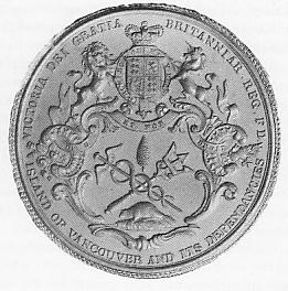
- Great Seal of the crown colony of Vancouver Island
- Measuring crustal motions in coastal British Columbia with continuous GPS
- BC Ministry of Transportation - Report on Fixed Link
|
|||||
|
|||||||||||||||||